


Safe Routes to School: Building Safer, Healthier and More Sustainable Journeys for Children
Lluis Sanvicens • 4 December 2025
Safe Routes to School: Building Safer, Healthier and More Sustainable Journeys for Children
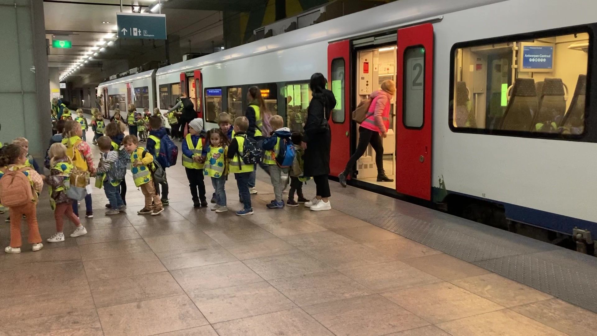
Ensuring that children can walk or cycle to school safely is one of the most impactful long-term investments a city can make in its future. Across Europe and worldwide, the Safe Routes to School (SRTS) movement has become a reference framework for designing school-mobility strategies that reduce traffic risks, promote active lifestyles, strengthen social cohesion and contribute to healthier, more sustainable urban environments.
Although the origins of the concept can be traced back to Denmark and the Netherlands in the 1970s, where early school-mobility programs focused on child safety and cycling culture, the initiative later gained major global momentum. In the United States, SRTS evolved into a well-structured, evidence-based program supported by national agencies, municipalities, schools and community organisations. Meanwhile, Europe has continued to expand its own models—such as School Streets, Vision Zero for school environments, Low-Traffic Neighbourhoods, and EU SUMP-based School Mobility Plans—making school travel a key priority in the continent’s sustainable-mobility agenda.
In the last decade, Safe Routes to School has resurfaced as a strategic response to emerging challenges: rising childhood inactivity, increased school-area congestion, road-safety inequalities, climate-change pressures, and the need for cities to become more resilient, walkable and people-centred.
Today, the principles of SRTS are fully aligned with global and European policy goals, including the EU Urban Mobility Framework, the European Road Safety Strategy (2021–2030), the WHO’s Global Plan for Road Safety 2021–2030, and local Sustainable Urban Mobility Plans (SUMP/PMUS) that encourage active, safe, low-emission school travel.
This article provides a comprehensive, in-depth overview of Safe Routes to School: what it is, why it matters, how it works, and how cities, schools and mobility consultants can successfully design and implement it within both European and international contexts.
Here is a slightly extended and enriched version of Section 1, keeping the structure, tone and length balanced while adding more depth and European relevance.
1. What Are Safe Routes to School?
Safe Routes to School (SRTS) is a holistic, multi-disciplinary approach that aims to make walking, cycling and other forms of active travel the safest, easiest and most attractive way for children to reach school. It is both a policy framework and a practical methodology, used today in hundreds of cities across Europe, North America and around the world.
Rather than focusing solely on infrastructure, the SRTS model integrates engineering, education, enforcement, encouragement, evaluation and community engagement. This combination ensures that school mobility is not only safe, but also enjoyable, socially supported, culturally normalized and fully integrated into broader urban-mobility strategies.
At its core, SRTS seeks to answer a fundamental question:
How can we design cities so that every child has the right to a safe, independent and active journey to school?
2. Why Safe Routes to School Matter
Safe Routes to School initiatives address some of the most pressing mobility, public-health and urban-quality challenges of contemporary cities. Their impact extends far beyond the school gate: they reshape neighbourhoods, reduce traffic danger, improve environmental conditions and strengthen community bonds. For municipalities, investing in safer school routes is one of the most efficient ways to leverage small-scale interventions for large-scale benefits.
2.1 Safety for Children
School journeys often involve navigating fast traffic, unsafe crossings, poorly designed intersections or chaotic drop-off areas. Across Europe, road incidents involving children tend to cluster around school arrival and departure times, highlighting the vulnerability of younger pedestrians and cyclists in car-dominated environments.
Reducing these risks — through traffic calming, safer crossings, reduced speed limits, school streets or controlled vehicle access — has a direct, measurable impact on children’s safety and on parents’ peace of mind. It also contributes to wider “Vision Zero” objectives for eliminating serious injuries and fatalities in urban settings.
2.2 Health, Activity and Wellbeing
Walking or cycling to school helps children meet daily physical-activity recommendations and supports healthy growth during critical developmental stages. The benefits go beyond physical fitness: active travel is associated with better concentration in class, improved mental health, lower stress levels and higher overall life satisfaction.
In a context where sedentary lifestyles and childhood obesity are rising across Europe, SRTS programmes offer a practical, everyday solution that embeds physical activity directly into children’s routines.
2.3 Reducing Congestion and Emissions
In many cities, up to 25–30% of peak-hour traffic near schools is generated by families driving their children — often for very short trips. This contributes to congestion, delays, noise, and elevated pollution levels precisely where children are most exposed.
By shifting these trips to walking, cycling or public transport, SRTS reduces unnecessary car journeys, cuts emissions, and improves air quality around schools.
2.4 Building Independence and Social Skills
Active travel helps children develop essential life skills: spatial awareness, route planning, decision-making, risk assessment, and social interactions with peers. These experiences foster autonomy and confidence, allowing children to explore their urban environment safely and responsibly.
Cities like Copenhagen, Amsterdam and Vienna consistently show that when safe conditions are provided, children naturally embrace independent mobility.
2.5 Stronger Community Identity
SRTS encourages collaboration between schools, families, municipalities, local police and neighbourhood groups. These partnerships strengthen communication, foster civic responsibility, and create shared ownership of the public spaces around schools.
Over time, school mobility programs help build cohesive, supportive neighbourhoods—places where residents look out for each other and where public spaces feel safer, friendlier and more human-centred.
3. The Five Pillars of the Safe Routes to School Approach
Safe Routes to School is anchored in a structured methodology widely known as the “6 Es”. This framework ensures that every factor influencing school mobility — from street design to human behaviour — is addressed in a coordinated, balanced and effective way. Each pillar plays a distinct role, but together they create an ecosystem where active travel becomes safe, attractive and fully integrated into daily life.
3.1 Engineering
Engineering covers all the physical interventions that shape how children move through public space. It includes creating continuous, accessible sidewalks, redesigning intersections for shorter and safer crossings, calming traffic with raised tables or speed humps, and providing dedicated space for cycling. In many schools, engineering also involves reorganising entrances, improving visibility, or removing conflict points between vehicles and children.
These measures form the tangible backbone of a Safe Routes program. They change the environment itself, making walking and cycling feel natural, intuitive and inherently safer.
3.2 Education
Education focuses on empowering children, caregivers and drivers with the knowledge and skills needed to navigate streets safely. This may take the form of pedestrian and bicycle safety sessions, classroom activities that reinforce good mobility habits, or awareness campaigns reminding drivers to reduce speed and remain vigilant in school zones.
When education is well-structured, new infrastructure is used properly, risks are reduced, and children gain confidence and independence in their daily journeys.
3.3 Enforcement
Enforcement ensures that the rules designed to protect children are respected. By controlling speed near school entrances, preventing dangerous parking behaviours, improving signage, and coordinating with local police or community volunteers, enforcement creates predictable traffic conditions. This stability is essential: children move more safely when drivers behave in a consistent, regulated way.
3.4 Encouragement
Encouragement is about making active travel appealing. When walking and cycling are celebrated — through walking school buses, bike trains, special event days or the simple act of sharing safe-route maps — children feel motivated to participate. Over time, these positive experiences help build new habits for both families and the school community.
Encouragement turns mobility from a necessity into an enjoyable part of the school day.
3.5 Evaluation
A successful Safe Routes program is grounded in measurable results. Evaluation involves observing how travel patterns change, analysing traffic speeds, collecting feedback from parents and students, and identifying areas where risk persists. This process ensures transparency and enables continuous improvement. It also provides clear evidence to support further investment.
3.6 Equity
Equity places fairness at the centre of school mobility planning. It acknowledges that some communities face greater barriers to safe travel — whether due to infrastructure gaps, socioeconomic conditions, or mobility limitations. By identifying these disparities and prioritising interventions where they are needed most, Safe Routes to School ensures that every child, without exception, has access to a safe and dignified journey.
4. How Safe Routes to School Programs Are Implemented
Implementing a Safe Routes to School program is a structured process that unfolds in clear phases. Each step builds on the previous one, ensuring that actions are coordinated, evidence-based and aligned with the needs of the school community.
The first step is to form a School–Community Working Group. This team typically brings together school staff, parents and caregivers, municipal mobility planners, police or traffic-enforcement officers, and professionals from public health or urban planning. By combining different perspectives and responsibilities, this group becomes the driving force of the project, ensuring that decisions are balanced and widely supported.
Once the team is established, the next phase involves gathering baseline data. Understanding existing conditions is essential: how children currently travel, which routes feel unsafe, where traffic conflicts occur, and what infrastructure gaps exist. This information is usually collected through mapping exercises, surveys, on-site observations, safety audits and traffic measurements. Together, these tools provide an accurate picture of the starting point.
With the data in hand, the working group moves on to analysing problems and identifying solutions. This stage involves prioritising interventions ranging from engineering improvements and traffic-management measures to behavioural programmes and educational activities. Every proposed action must be realistic, budget-conscious and compatible with wider municipal strategies, ensuring that implementation is both practical and sustainable.
These decisions are then consolidated into a School Travel Plan—a formal document outlining the objectives, actions, timelines and responsibilities of each stakeholder. The plan serves as a roadmap that guides the project from ideas to execution.
The next phase is the implementation itself. Improvements to infrastructure, operational adjustments around the school, awareness activities and mobility programmes are deployed, often in stages to allow flexibility and minimise disruption. The goal is to create noticeable, positive changes in the daily school journey as early as possible.
Finally, a Safe Routes to School program closes the loop with monitoring and evaluation. Travel patterns are compared before and after the interventions, and indicators such as walking and cycling rates, traffic reduction, perceived safety, accident data and community engagement are assessed. This evidence not only measures success but also helps refine strategies and supports long-term decision-making.
Here is Section 5 rewritten in a smooth, narrative style, integrating all the content but removing the heavy bullet structure. It keeps the technical precision while offering a pleasant, flowing reading experience.
5. Typical Measures in a Safe Routes to School Plan
A Safe Routes to School plan usually combines a wide range of interventions that work together to make school journeys safer, more efficient and more appealing. Although every school and neighbourhood is different, most plans include actions across four major areas: infrastructure, traffic management, programmes and community participation.
5.1 Infrastructure
Infrastructure improvements provide the physical foundation for safer and more comfortable school travel. These may include widening sidewalks to ensure continuous and accessible walking routes, adding raised crossings or kerb extensions to give children better visibility, or redesigning intersections to eliminate conflict points with vehicles. In areas with substantial bicycle use, protected cycle tracks near schools help create a dedicated and predictable environment for young cyclists.
Many schools also incorporate kiss-and-go zones, which are short-stay drop-off areas designed to reduce chaos directly in front of the school entrance. A kiss-and-go area provides a designated space where caregivers can stop briefly, let children exit the vehicle safely, and move on without parking. When designed correctly—with clear signage, proper curb alignment and safe pedestrian access—these zones significantly reduce congestion and improve safety in the immediate school frontage.
5.2 Operation and Traffic Management
Operational and traffic-management measures complement the physical redesign of school surroundings. These strategies shape how vehicles, buses and pedestrians interact at peak times, helping to reduce conflicts and create predictable movements.
Some schools adopt one-way circulation systems during drop-off and pick-up hours, or temporarily restrict vehicle access near the entrance to prioritise children’s safety. Parking regulations help prevent dangerous behaviour such as double-parking, blocking sightlines or stopping in prohibited zones. In areas with high public-transport use, dedicated bus lanes or priority areas ensure more efficient operation and better safety for students.
From an operational perspective, kiss-and-go zones also require clear rules and supervision. This may involve establishing short time limits, defining exact stopping positions, or assigning staff or volunteers to assist during peak periods. These small adjustments ensure that the drop-off process remains fluid and safe, complementing the physical design of the zone.
5.3 Programmes and Activities
Beyond infrastructure and traffic management, Safe Routes to School initiatives rely on community programmes that promote active travel. Walking school buses—groups of children walking together under adult supervision—provide a structured, safe and social way to reach school. Schools often organise “Active Mobility Days,” road-safety events or bicycle training sessions to reinforce good habits and build confidence among students.
Mobility maps, showing recommended walking and cycling routes, help families identify safer ways to reach school and encourage a shift away from private cars.
5.4 Governance & Participation
Strong governance and active participation are essential for a successful Safe Routes plan. Continuous dialogue between the school and the municipality ensures alignment between daily needs and long-term mobility strategies. Teachers, family associations and local residents contribute valuable insights that help prioritise interventions and maintain community support.
Workshops with children provide an especially important perspective. Their experiences, preferences and concerns often reveal issues that adults overlook, and involving them in the process fosters a sense of ownership and empowers them as active participants in shaping their school environment.
Conclusion: Designing School Journeys That Shape Better Cities
Safe Routes to School is far more than a mobility initiative. It is a commitment to designing cities where children can move safely, confidently and independently — and where streets support healthier, more sustainable lifestyles for all. By combining infrastructure improvements, careful traffic management, education, community involvement and continuous evaluation, SRTS programs create school environments that are calmer, safer and more inclusive.
The benefits extend well beyond the school gate: reduced congestion, cleaner air, stronger neighbourhood ties and public spaces that prioritise people over vehicles. When children gain the freedom to walk or cycle safely, the entire community thrives.
Implementing Safe Routes to School requires coordinated effort and a thoughtful approach, but the return on investment is immediate and long-lasting. It improves daily life for families, enhances wellbeing, and helps cities progress toward broader goals in sustainability, safety and urban quality.
Ultimately, creating safe school routes is not simply about mobility — it is about shaping the kind of cities we want future generations to inherit: cities that place children at the centre, protect their right to move safely, and recognise that streets designed for the youngest residents tend to be better streets for everyone.
References
Federal Highway Administration. (2008). Safe Routes to School: Program guidance. U.S. Department of Transportation. https://www.fhwa.dot.gov/environment/safe_routes_to_school/
European Commission. (2013). Guidelines: Developing and implementing a sustainable urban mobility plan (SUMP). Publications Office of the European Union.

Discover a comprehensive methodology for assessing urban cycling networks using GIS, safety analysis, demand assessment, and prioritisation of improvement measures.
Descubre una metodología integral para evaluar redes ciclistas urbanas mediante indicadores, análisis GIS, seguridad vial y priorización de actuaciones para mejorar la movilidad activa.

Technical overview of the methodology used to calculate external transport costs, including accidents, congestion, air pollution, climate change, noise and environmental impacts, with practical examples and applications in mobility planning.
Artículo técnico sobre la metodología para el cálculo de los costes externos del transporte, incluyendo accidentalidad, congestión, contaminación atmosférica, cambio climático, ruido e impactos ambientales, con ejemplos prácticos y aplicaciones en planificación de la movilidad.

Qué es la tokenización y cómo se aplica en movilidad: billetaje digital, pagos, datos y MaaS para sistemas más eficientes, seguros e interoperables.

A technical, practice-oriented explanation of urban transport corridors as the key functional scale for diagnosing problems and planning efficient urban mobility systems.

Explicación técnica y aplicada del corredor de transporte urbano como escala funcional clave para diagnosticar problemas y planificar la movilidad urbana.

How to assess transport projects, compare alternatives, analyse demand and apply robust appraisal methods to choose the most effective mobility investment.
Guía clara para entender los estudios de viabilidad y la evaluación de proyectos en transporte y movilidad. Cómo decidir inversiones con rigor y datos.

La Ley de Movilidad Sostenible 2025 define nuevos planes para administraciones y empresas, combinando obligaciones, incentivos y oportunidades de financiación.